Vietnam Adventures
Geography

 |
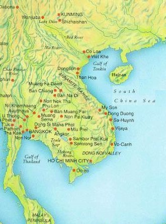 |
Viet Nam Topography Map |
| |
| |
|
Topography
Viet Nam is long and narrow, with a 1,400-mi. coast. About 24% of country is
readily arable, including the densely settled Red River valley in the North
VietNam (Bac Viet), narrow coastal plains in the Central VietNam (Trung Viet),
and the wide, often marshy Mekong R. Delta in the S. The rest consists of
semi-arid plateaus and barren mountains, with some stretches of tropical rain
forest.
Land and Resources
Viet Nam occupies the easternmost part of the Indochinese Peninsula, a rugged,
elongated S-shaped strip of mountains, coastal plains, and river deltas.
|
|
|
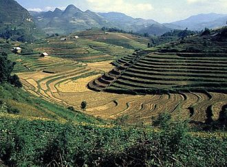 |
Rice Fields on Hillside in North Viet Nam Highland |
| |
| |
|
Physiographic Regions
Viet Nam may be divided into four major regions. In the northwest is the mountainous
southern extension of China's Yunnan Plateau. The country's highest peak, Fan Si Pan
(3143 m/10,312 ft), is located near the border with China. To the east of the highlands
is the Red River (also known as the Song Hong) delta, a triangularly shaped lowland
along the Gulf of Tonkin (an arm of the South China Sea). To the south the Annamese
Highlands, which run northwest to southeast, and an associated coastal plain form the
backbone of central Viet Nam. The fourth and southernmost region is the Mekong
River delta, a depositional area of flat land.
Soils
The soils of the Red River and Mekong River deltas, the two major deltas of Viet Nam,
are composed of rich alluvium except where damming for flood control has altered the
stream flow. Soils in the uplands are poor as a result of leaching of nutrients from the
ground by the abundant rainfall.
|
|
|
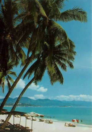 |
Beautiful White Sand Beach at Nha Trang - Central Viet Nam |
| |
| |
|
Climate
Three basic climate types are found in Viet Nam. In the north, especially in the interior,
the temperatures are subtropical. Shifting seasonal wind patterns result in dry winters
and wet summers. The central and southeastern areas typify the tropical monsoon
climate, with high temperatures and abundant precipitation. In the southwest, distinct
wet and dry periods are evident, but temperatures are higher than in the north.
Vegetation and Animal Life
Abundant vegetation exists throughout Viet Nam except where the landscape has
been denuded. Typical mixed stands in the rain forests contain a wide variety of
pines, broadleaf trees, vines, and bamboos. Dense mangroves bordering the
distributaries of the deltas often hinder access to the water's edge. The tropical rain
forests are inhabited by large mammals such as elephants, deer, bears, tigers, and
leopards. Smaller animals, including monkeys, hares, squirrels, and otters, are found
throughout the country. Reptiles such as crocodiles, snakes, and lizards, as well as
many species of birds, are also indigenous.
|
|
|
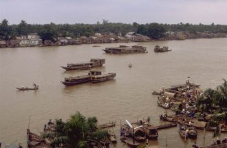 |
Boats on Mekong River - Can Tho - South Viet Nam |
| |
| |
|
Rivers
The Red River in the north and the Mekong River in the south are the two major
freshwater streams. The Red flows almost directly southeast from the northwestern
highlands, whereas the Mekong follows an irregular path from Cambodia, crosses
southernmost Viet Nam, and empties in the South China Sea through a complex
network of distributaries. Both rivers have been leveed to prevent flood damage.
Mineral Resources
The northern highlands of Viet Nam contain valuable minerals, including iron,
anthracite coal, phosphate, zinc, chromite, tin, and apatite. Petroleum and natural
gas deposits lie offshore.
|
|
|